Water and Sewer Programs
Learn about Markham's ongoing water and sewer programs.
Flood Control Programs
Learn more about Markham's Water, Flood Control & Stormwater Operation and Maintenance and Rehabilitation Programs
- Markham Flood Control Program

What is Markham’s Flood Control Program?
In February 2013, Council approved a long-term 30-year Flood Control Program which sets funding requirements to achieve level of service improvements for drainage systems in the City of Markham.
The Flood Control Program is a long term, City-wide initiative to improve storm drainage capacity and limit surface and basement flooding risks in urban areas. Improvements will provide a more consistent level of service across Markham and help protect both public and private property. The program will also make critical infrastructure more resilient to climate change and extreme weather.
The City has prioritized the assessment and upgrade of older drainage systems, constructed prior to 1978, when modern day standards for stormwater drainage were implemented. Areas constructed prior to 1978 are more susceptible to flooding as they were not designed to convey the amount of water expected during infrequent, very large storm events.
The Citywide Flood Control Program includes projects that range from major capital improvements to the storm system, to education programs and subsidies for residents to improve their private plumbing systems.
Staff updated the cost estimates in 2018 for all phases of the Flood Control Program, with an estimated cost of $367-$382M. To date, the City has received two funding grants for the program:
- $6.5M from the Clean Water and Wastewater Fund (CWWF) – Ministry of Infrastructure of Ontario
- $48.6M from the Disaster Mitigation and Adaptation Fund (DMAF) – Infrastructure Canada
In 2013, Council approved the allocation of $2M per year from the Federal Gas Tax Grant. The costs of the program are otherwise funded by the City’s stormwater fee, charged to all property owners; residential and non-residential. This fee is applied to the Final Tax bill for each property owner in Markham. For more information, visit Stormwater Fee


Flood Control Projects
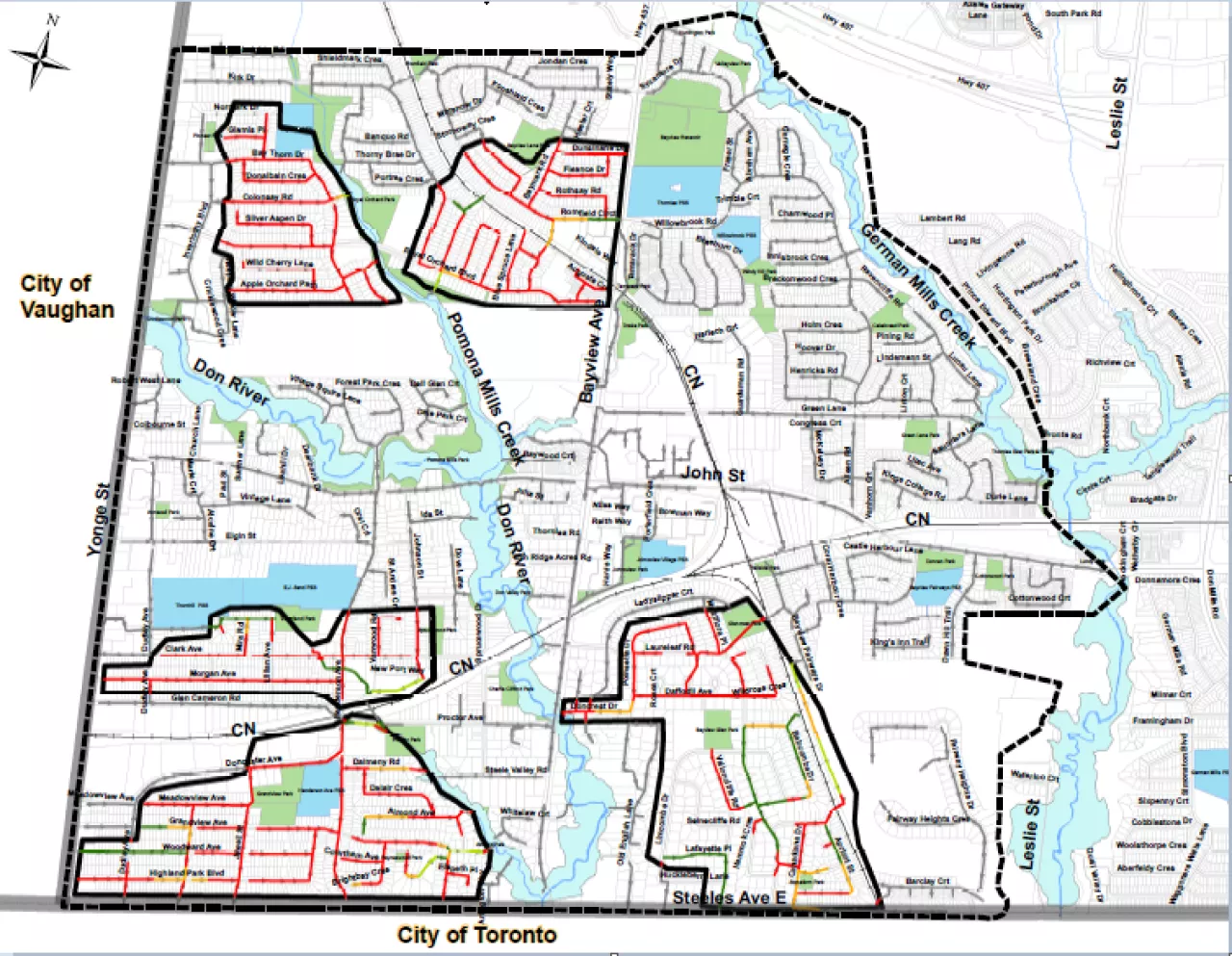
The City has prioritized the upgrades within West Thornhill, the Don Mills Channel (Woodbine/Denison Area) and Markham Village and Unionville, based on the known locations of basement flooding clusters. Other areas within the City will be assessed at a later date. The current status and location of all areas to be assessed through the program are shown in the maps below.
For more information on our flood control projects, please see the following links below:
- Don Mills Channel
- West Thornhill
- Markham Village & Unionville
- Glynnwood Tributary Area Sewer
- Private Plumbing Protection Program

Stormwater Fee
To help fund the program, a Stormwater Fee is charged to all properties in the City of Markham. This fee, combined with revenue from the Canada Gas Tax and other grants, will provide dedicated funds for both approved and future Stormwater infrastructure improvement projects City-wide.
Council Decisions and Resolutions:
- Project Needs Workshop (May 15, 2012)— see Workshop Presentation and Workshop Minutes
- Recommendations for a City-Wide Flood Control Strategy (November 8, 2012)— General Committee Presentation and General Committee Minutes
- Council Decision Regarding Flood Control Strategy (February 12, 2013)— see Council Presentation and Council Minutes
- Feedback from Community Meetings (June 10, 2013)— see General Committee Report, Community Information Meeting summary and General Committee Minutes
- Framework on Annual Flood Control Strategy Costs (Gas Tax) (October 28, 2013)— see Presentation and Council Resolution
- Annual Flood Control Strategy Costs (Stormwater Fee) (November 18, 2013)— see Presentation and Council Resolutions
- Stormwater Funding Implementation and Communication Plans (May 26, 2014)— see Presentation and Council Resolutions
- West Thornhill Flood Remediation (June 24/25, 2014)— see Presentation and Council Resolutions
- Status Update on Implementation of Stormwater Fee (November 25, 2014)— see Presentation, Report, Bylaw, and Council Resolutions
- Business Consultation Meetings (April 9, 2015 & April 14, 2015 )— see Presentation
- Stormwater Fee Non-Residential Consultation and City-Wide Implementation (June 15, 2015)— see Report
- Stormwater Fee Non-Residential Consultation and City-Wide Implementation (September 9, 2015)— see Memorandum
- Flood Control Program and Stormwater Fee Update (April 8, 2019)— see Report
- Council Meeting Flood Control Program and Stormwater Fee Update (September 24, 2019)— see Report and Presentation
Disaster Mitigation And Adaptation (DMAF) Funding
The Government of Canada launched the Disaster Mitigation and Adaptation Fund (DMAF), a $3.375 billion national merit-based program that supports large-scale infrastructure projects to help communities better manage the risks of disasters triggered by natural hazards.
The City’s $48.6M DMAF grant funds a portion of the following projects under the City’s Flood Control Program:
1. West Thornhill Flood Control Implementation – Phases 3 & 4;
2. Don Mills Channel Flood Control; and
3. Thornhill Community Centre floodproofing and Glynnwood Storm Sewer Upgrades.
Detailed are provided in the City staff report (April 8, 2019) and project webpages.
- Don Mills Channel Flood Protection
Don Mills Channel Flood Protection
Background
The Don Mills Channel is a small man made channel that runs through the commercial / industrial area in the Woodbine Avenue and Denison Street area.
The Channel was realigned and straightened in the 1960s in preparation for development. Over time, several sections of the channel were enclosed to provide more parking spaces on private sites, and the channel now consists of a combination of open channels and enclosed sections. The majority of the open channel and enclosed sections are located on private property, with easements for the City to inspect and maintain the system.
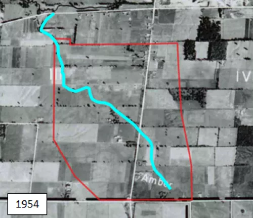
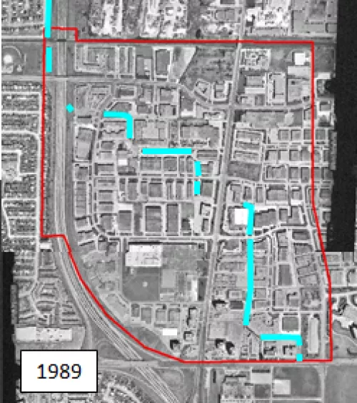
Businesses surrounding the Don Mills Channel have flooded numerous times since the land was developed. Major roads in the study area, including Woodbine Avenue, can be impassable during severe storms.
The reason this area is at higher risk of flooding is its limited capacity for carrying floodwater. The current system of storm sewers, open channels, and culverts was designed in the 1960’s to carry moderate storm events. The system does not have adequate capacity to handle stormwater during intense rainfall events.
Damage to property and assets may occur during severe thunderstorms and flooding.
The City of Markham has made significant infrastructure investments in flood control improvements. See here for the latest on the Don Mills Channel Flood Reduction Program.
The City has also developed a Floodproofing and Education Program to assist property owners and tenants within this area to identify site-management and floodproofing measures to protect their properties and assets against flood damage.Study Area

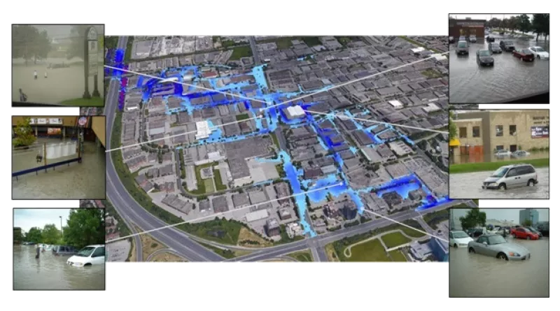
Estimated Flooding
This image shows the predicted extents of flooding from the August 19, 2005 storm event within the study area, and pictures taken during and shortly after the storm.
Don Mills Flood Reduction Environmental Assessment
A Class Environmental Assessment (EA) study for the Don Mills Channel Flood Reduction was completed and approved in 2018. The purpose of the Class EA study was to:
- Identify and understand the causes of flooding in the study area;
- Develop a range of alternative solutions to reduce flooding and flood damages from the Don Mills Channel;
- Recommend the preferred solution or suite of solutions to best reduce flooding and flood damages; and
- Establish the funding, approvals and other activities needed to implement the recommended solutions.
The Study Objective is to provide flood protection for a Council Approved 5 year Level of Protection for the Don Mills Channel Area, as per the Council Resolution (February 2018)
Preferred Alternative
The following Preferred Alternative was proposed from the findings in the Class EA Study for the Don Mills Channel Flood Reduction (A map of the proposed works is shown below):
Design/construction of a central municipal flood storage facility upstream of Steelcase Road East with a proposed storage volume of 37,000 m3;
Replacement and upgrade of existing corrugated steel pipe culverts at Steelcase Road East, Woodbine Avenue, Denison Street and Steelcase Road West; and
Implementation of a flood proofing and education program in the Don Mills Channel area.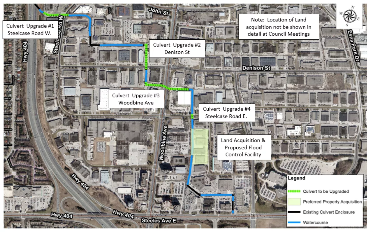
Project Implementation Schedule
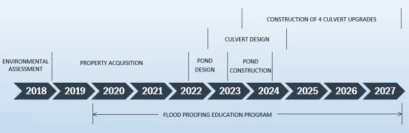
The design of the flood storage facility (i.e., dry pond) is complete and the Class EA Study’s Preferred Alternative has been refined to avoid the need for any online control structures. Remaining buildings were removed in 2023 and pond construction is being initiated in 2025. Culvert design is ongoing.
Documents, News & Resources
- Don Mills Channel Capacity Study, June 26, 2007
- Don Mills Channel EA Overview, February 28, 2018
- Don Mills Channel Implementation Strategy, June 12, 2018
Environmental Assessment Files
- Notice of Study Commencement , January 21, 2016
- Public Meeting # 1 Boards , November 9, 2016
- Presentation to General Committee (February 20) on the Preliminary Preferred Alternative , February 20, 2018
- Public Meeting #2 Boards , April 4, 2018
- Notice of Completion , July 27, 2018
- Final ESR Document , July 27, 2018
Don Mills Channel Maintenance Program
An inspection and maintenance program for the open portions of the channel, as well as culvert inlets, was also initiated in 2017 to retain the conveyance capacity and reduce flooding potential. The program consists of the assessment and removal of live vegetation/trees, deadfall, garbage, and deposited sediment (as required).
City infrastructure (sanitary sewer, stormwater outfalls) potentially at risk of flooding or erosion in this area are also inspected regularly. Erosion risk for private properties bordering the channel is assessed periodically. Culverts are inspected following major rain events to make sure debris is not lodged in front of the culverts. City staff will remove and dispose of any significant accumulation of debris.
What can you do?
- Avoid storing equipment, vehicles and other assets in the floodplain, especially during storms
- Do not dump garbage on the channel bank or in the channel
- Do not encroach into the channel. Any encroachment will need to be removed, and the channel be restored to its original condition.
Contact Information:
Robert J. Muir, M.A.Sc., P.Eng. ,
Manager, Stormwater
8100 Warden Ave., Markham, Ontario L6G 1B4
905.477.7000 extension 2357 | rmuir@markham.ca
- West Thornhill Flood Remediation
Background
On August 19, 2005, the West Thornhill community was impacted by a severe rain storm during which stormwater runoff exceeded the capacity of drainage systems, causing extensive flooding of private property and roadways. The storm was characterized by high rainfall intensities and volumes which resulted in the flooding of many basements in homes and institutions as well as watercourse erosion, and damage to the City’s infrastructure such as roads, culverts, sewers and watercourses


Environmental Assessment
A Class Environmental Assessment (EA) study for the West Thornhill Stormwater Flood Remediation Study was completed and approved in August 2011. The purpose of the Class EA study was to:
- Identify and understand the causes of flooding in the study area;
- Develop a range of alternative solutions to increase capacity and reduce flood risks in West Thornhill;
- Identification and prioritization of the causes of basement flooding and surface flooding;
- Evaluation of various flood remediation measures and develop a comprehensive remediation plan for the areas identified as highest priority and most likely to flood again in the future.
Preferred Alternative
The following Preferred Alternative was proposed from the findings in the Class EA Study for the West Thornhill Stormwater Flood Remediation Study:
- Roof downspout disconnections;
- New inlet control devices in catchbasins that limit the inflow to sewers;
- Increased sewer inlet capacity at key locations where sewer capacity is available; and,
- Storm sewer upsizing and inlets within and downstream of the high flood potential areas as well as ‘diversion’ pipes that reduce flows at critical locations relieving overloaded sewers.
Improvement Areas
High priority locations for storm sewer upgrades identified through the EA study
Locations of the proposed upgrades
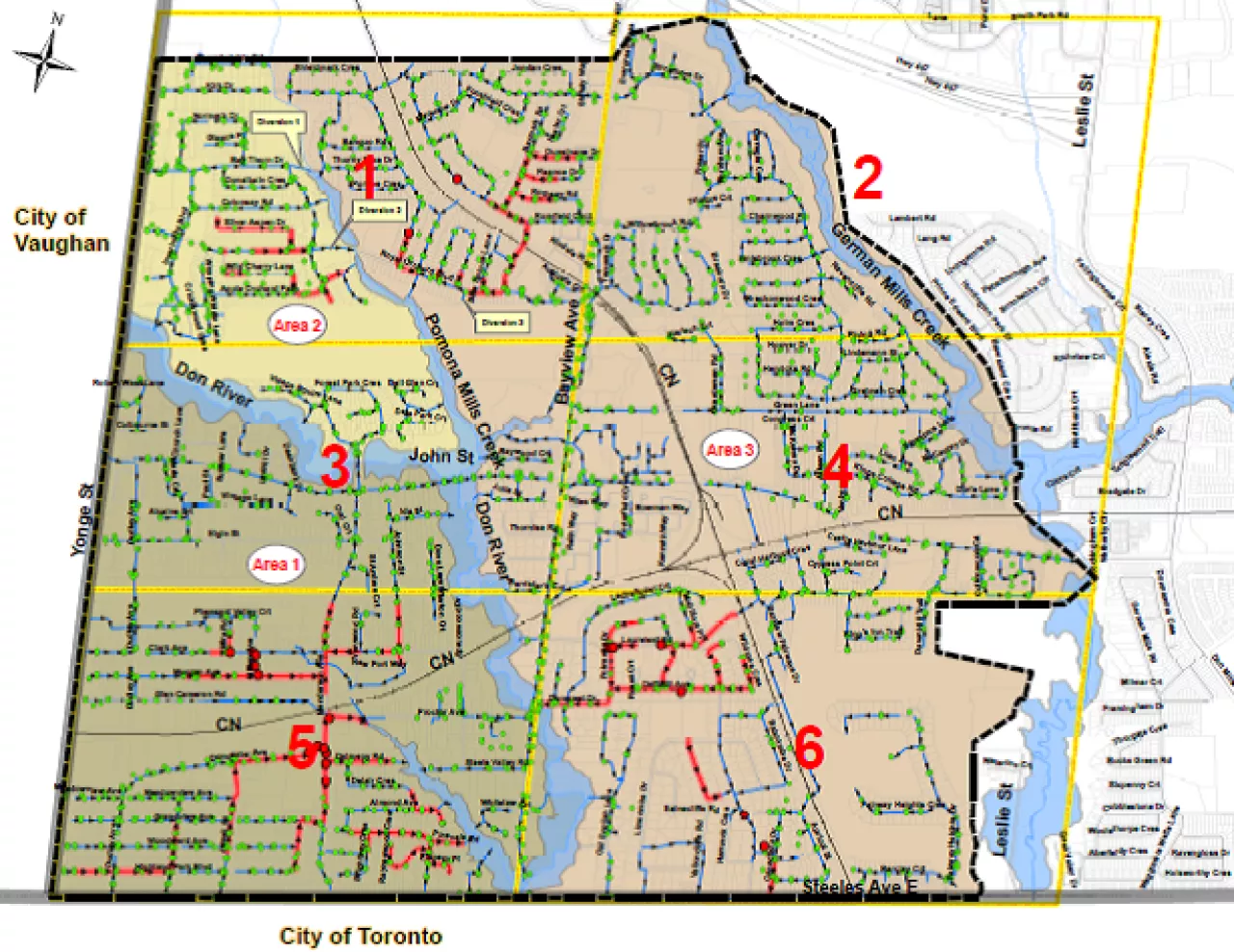
Project locations
Implementation Schedule and Documents
An implementation strategy was adopted in October 2011 that defined phases of design and construction projects throughout the community based on flood risk priorities. West Thornhill Flood Control is a consistent with principles of Markham’s asset management plan for stormwater infrastructure, including meeting desired level of service related to flood risk mitigation. Construction phases are shown below.
Construction of Phase 1, Phase 2, Phase 3 and Phase 4A / 4B areas is complete. Finalization of Phase 4C / 4D area design is on hold pending completion of the Yonge Street Corridor Secondary Plan that will address servicing needs through a portion of these areas.
Area Proposed Implementation Schedule Status Phase 1A: Bayview Glen Area 2014 — 2015 Substantially completed as of Nov 2015;
Maintenance completion Nov 2017Phase 1B: Bayview Glen Area 2015 — 2016 Substantially completed as of Aug 2016;
Maintenance completion Aug 2018Phase 1C: Canadiana Road 2016 Substantially completed as of Dec 2016;
Maintenance completion Dec 2018Phase 2A: Grandview Area 2016 — 2017 Substantially completed as of Dec 2016;
Maintenance completion Dec 2018Phase 2B: Grandview Area
(Park & Proctor Ave)2017 — 2018 Substantially completed as of Dec 2017;
Maintenance completion Dec 2019Phase 2C: Grandview Area 2018 — 2019 Substantially completed as of Nov 2019;
Maintenance completion Nov 2021Phase 2D: Grandview Area 2019 — 2020 Substantially completed as of Nov 2019;
Maintenance completion Nov 2021Phase 3A: Clark Ave./Henderson Area
(This Area)2020-2021 Substantial completion Aug 2021
Maintenance completion Sept 2023
Phase 3B: Johnson Street from Clark Avenue to John Street and watermains (St, Andres Court, Ida Street, Dove Lane, Wiarton Court) 2021 Substantial completion Oct 2021
Maintenance completion Oct 2023
Phase 3C: Glen Cameron Road/ Clark Ave/ Lilian Ave/ Mira Road/ Pheasant Valley Crt 2022-2023 Substantial completion Sept 2023 Phase 4A: Royal Orchard Area / Kirk Drive 2021- 2022 Substantial completion Nov 2022
Maintenance completion Nov 2024
Phase 4B: Romfield Circuit 2023-2024 Substantial completion June 2024
Related Information:
- West Thornhill Stormwater Flood Control Implementation Strategy (West Thornhill Stormwater Flood Control Implementation Strategy)— see Report and Presentation
- Presentation to GC (October 31, 2011) — see Excerpt
- Presentation to Council (October 31, 2011) — see Presentation
- Council Resolution (November 8, 2011)— see Resolution
- Award reports:
- Phase 1 Design (April 23, 2012)— see Report
- Phase 1A Construction Services (June 16, 2014)— see Report
- Phase 1C and Phase 2 Design (November 17, 2014) see Report. Phase 1B Construction Services (February 20, 2015) see Report
- Phase 2A & 1C Construction Administration Services (February 5, 2016)— see Report
- Phase 2A Construction Services (February 5, 2016)— see Report
- Phase 1C Construction Services (April 14, 2016)— see Report
- Phase 2B, 2C, 2D Construction Administration Services (February 6, 2017)— Report
- Phase 2B Construction Services (April 18, 2017)— see Report
- Phase 3 Design Services (May 1, 2017)— see Report
- Clean Water and Wastewater Fund (CWWF) (September 18, 2017 )— Report
- Phase 2C Construction Services (May 7, 2018)— see Report
- Phase 4 Design Services (June 12, 2018)— see Report
- Phase 2D Construction Services (February 19, 2019)— see Report
- Phase 3A Construction Services (March 2, 2020)— see Report
- Phase 3B Construction Services (April 6, 2020)— see Report
- Phase 3C Construction Services (April 19, 2022)— see Report
- Phase 4A Construction Services (April 6, 2020)— see Report
- Phase 4B Construction Services (February 21, 2023)— see Report
Community Information Meetings:
- Phase 3C Community Information Meeting (February 21, 2023)— see Presentation
- Phase 4A Community Information Meeting (February 21, 2023)— see Presentation
- Phase 4B Community Information Meeting (February 21, 2023)— see Presentation
For more information, please contact:
Robert Muir, Manager, Stormwater
Email: rmuir@markham.ca
Phone: 905.477.7000 x 2357- Downspout Disconnection Program

As of December 6, 2022, the Citywide Multi-Phase Sanitary System Downspout Disconnection Program has been successfully completed by investigating and disconnecting identified downspouts that connected to the sanitary sewer system within the high risk of basement flooding area in Thornhill, Unionville and Markham Village. As part of the City’s ongoing effort to reduce the risk of basement flooding and sewer backup, the City staff will continue to monitor sewer conditions through the annual inspection and monitoring program, review flood reports from large weather event and collect feedback from residents and community to help identify and develop remediate measures for areas with high risk of basement flooding potential.
This multi-phase program was implemented to reduce the risk of basement flooding, and to limit environmental concerns caused by directly connecting downspouts to the sanitary sewer system. These connections increase the flow of rainwater into the sanitary sewer system during heavy or long rain events. This can cause:
- The sanitary sewer system to overflow
- Sanitary sewer backups
- Basement flooding
This program also enforces the existing City of Markham Sewer By-Law # 2014-71 (PDF) [Clauses 3.1D & 19.11]. It also enforces the Region of York’s Sewage and Land Drainage By-Law # S-0064-2005-009, which prohibits the discharge of roof drainage water into the sanitary sewer system.
This program was done in six phases.
Phase 1 Program Area: The first phase of the program began in May, 2013 within the Thornhill area. The investigations and testing work within the Phase 1 Area (PDF) was finished in April 2014. The downspout disconnection work has been finished. Flow monitoring within the area started in Spring/Summer 2016.
Phase 2 Program Area: The second phase of the program began in May, 2014 within the Thornhill Area. The investigation and testing work with Phase 2 Area (PDF) was finished in April 2015. The notice of disconnection was mailed out to affected homeowners in June, 2015. The downspout disconnection work has been finished. Flow monitoring within the area commenced in Spring 2017.
Phase 3 Program Area: The third phase of the program began in May, 2015. It covered areas within Thornhill, Milliken, and Unionville. The investigation and testing work within the Phase 3 Area (PDF) ended in April, 2016. The downspout disconnection work has been finished.
Phase 4 Program Area: The fourth phase of the program began in May, 2016 within the Markham Area. The investigations and testing work within the Phase 4 Area (PDF) ended in February 2017. The notice of disconnection was mailed out to affected homeowners in September 2017.
Phase 5 Program Area: The fifth phase of the program began in May 2017, which covers area within Thornhill and Unionville. The investigation and testing work within the Phase 5 Area (PDF) was completed in November 2017. The notice of disconnection was mailed out to the affected homeowners in Fall 2018 and the disconnection period ended in Fall 2019. Post condition flow monitoring within the area commenced in Spring/Summer 2020.
Phase 5 Expansion Program Area: The fifth phase expansion of the program began in September 2017, which covers area within Thornhill and Markham Village. The investigation and testing work within the Phase 5 Expansion Area (PDF) started in November 2017.
Phase 6 Program Area: The sixth phase of the program began in September 2017, which covers areas within Unionville and Markham Village. The investigation and testing work within the Phase 6 Area (PDF) commenced in June 2018.

Steps taken by City to identify downspout discharge locations
Before any downspouts are disconnected, the City needs to confirm whether the downspouts that go into the ground are actually connected to the municipal sanitary sewer system. To do this, the City takes following steps:
- Preliminary property investigation
We do general surveys of residential lots to see whether downspouts are discharging above the ground or into the ground.
- Sanitary & storm sewer smoke testing
We do smoke testing within the sanitary and storm sewer systems. This involves blowing a non-toxic, highly visible smoke through the systems and observing the exit points of the smoke. This test finds whether downspouts that go into the ground are connected into the sanitary sewer system or the storm sewer system. The smoke test also identifies other devices/equipment that are connected to the underground sewer system.
Identified downspouts that discharge into the municipal sanitary sewer system
After the investigations and testing were finished, the City sent a Notice of Disconnection to homes with downspouts connected to the sanitary sewer system. The notice showed which downspouts need to be disconnected. More information was provided about how to disconnect a downspout and use rain barrels when the downspout disconnection stage started.
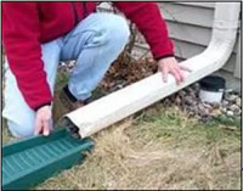
How to disconnect a downspout
- Ensure there is a suitable area for the water to discharge from the downspout
- Ensure downspouts are disconnected and drained properly away from the foundation walls and directly to a storage device (e.g. a rain barrel), your lawn, or garden.
- When disconnecting downspouts, remember not to drain directly onto neighbouring properties, lanes, or sidewalks.
- Extend your downspout to discharge water at least 1 metre from any structure's foundation (including your neighbour’s) or public sidewalk, and 2.5 metres from retaining walls.
- Ensure the ground slopes away from the house for a minimum of 1 metre.
- Use a splash pad to help direct the flow of water and protect against erosion.
- Ensure eavestroughs are clean and drain properly.
- Obtain professional advice and service from a knowledgeable and licensed roofer, eavestrough contractor, or civil engineer.
Read this Step-by-step procedure to disconnect your downspouts (PDF)
Using Rain Barrels
Rain barrels collect water from downspouts and rooftops and decrease the amount of storm water runoff that leaves your property. Using a rain barrel can help you lower your water bill and improve your lawn and garden.
Click here to learn more about rain barrels.
Helpful Links
- Downspout Disconnection Brochure (PDF)
- Council Minutes 2018
- Council Minutes September 2017
- Council Minutes 2017
- Council Minutes 2016
- Council Minutes 2015
- Council Minutes 2014
- Council Minutes 2013
- Every Downspout Counts Newsletter (PDF)
- Multi-Phase Program Map is available upon request.
Contact Us:
Help is only a phone call away! Waterworks staff will be more than happy to help you. Please call us at 905.477.5530.
- Backflow Prevention Program
The City’s backflow prevention bylaw reduces the chance of water contamination through backflow incidents at cross connections. Please see Markham's Backflow Prevention By-law 2012-29 (PDF).
Operations, Maintenance and Rehabilitation Programs
- Stormwater Management Facilities Maintenance
Stormwater Facilities Overview
Stormwater management facilities, or stormwater ponds, have been used to control stormwater from urban areas in Markham since the late 1980s, intended to ensure that new development does not increase or change the conditions for downstream landowners. When first introduced, most stormwater ponds were dry, and designed to store water in order to prevent flooding and erosion downstream. They have evolved over time to also include a permanent pool of water used to trap sediment and prevent contaminants from our roads and subdivisions from entering our watercourses.
While ponds can appear as attractive, natural features, and are often surrounded by trails and parks, the public is encouraged to exercise caution around these facilities, as conditions in stormwater management ponds can change rapidly due to fluctuating water levels and hazards associated with deep pools, fast moving water at inlets and outlets, and thin ice.
As of January 2025, the City owns and maintains 123 stormwater ponds. Several new facilities are added in the City of Markham each year.


Sediment Excavation During Pond Cleanout
The City has a program to remove sediment from each pond, a practice that is completed at a frequency mandated by the Ministry of Environment, Conservation and Parks. This activity, called dredging, is undertaken approximately every 20 years, and involves draining the pond and removing the sediment that has been captured by the pond. City staff confirm the theoretical frequencies by periodically measuring actual sediment levels.


Maintenance Requirements
In addition, the City conducts a full inspection of each stormwater facility every year to make sure that it is performing as originally designed. Based on these annual inspections, general maintenance is performed as required. This includes litter pickup, vegetation management, and removal of any blockages in the infrastructure at each pond.
Visit Environmental Services Current Projects for further information on ongoing projects.
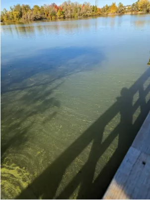
Algae Growth and Colour Sheens
Stormwater ponds are designed to trap contaminants in order to protect the downstream watercourse. The growth of algae in stormwater ponds, while not aesthetically pleasing, is a common occurrence, especially during hot and dry summers. The contaminants trapped by a stormwater pond will often contain nutrients, which promote the growth of algae. The degree that algae grows in a pond is driven by a variety of factors, which are very difficult (or impossible) to control.


From time to time, colour sheens are observed on pond water surfaces. Often these sheens have a rainbow-like appearance. In some cases, a reddish precipitate can also be seen in the water where these sheens occur. While colour sheens may be caused by petroleum spills, they are often a result of the contaminants that are trapped in the specific pond. Generally, if no petroleum odour is present, this is likely not a petroleum spill. If you observe a colour sheen in the pond, please contact the City and we will investigate.
For more information, please contact:
Robert Muir Manager, Stormwater
Email: rmuir@markham.ca
Phone: 905.477.7000 x 2357- Sanitary and Storm Sewer Inspection, Condition Assessment and Repairs
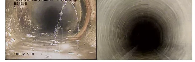
The City of Markham conducts closed-circuit television (CCTV) inspection, condition assessment and repairs for all City’s storm and sanitary sewer pipes on a 10-year rotation basis.
Approximately 80 km of storm sewers and 80 km of sanitary sewers will require inspection within a year.

Based on the condition assessment for CCTV inspection of storm and sanitary sewer pipes, City implements storm and sanitary sewer pipes and laterals repairs / rehabilitation by CIPP full lining, spot lining, grouting and cleaning trenchless method or open cut method.
The implementation of CCTV inspection, condition assessment, and sewer rehabilitation is critical to maintaining the integrity and efficiency of the City’s sanitary and storm sewer systems.
By adopting a proactive approach, the City can reduce costly emergency repairs, ensure regulatory compliance, and provide reliable sewer services to residents.
Investing in these initiatives will safeguard public health, protect the environment, and enhance the longevity of the City’s underground infrastructure.
For more information about this program, please contact the following:
Philip Zhang, Project Engineer
905.477.7000, Extension 2477
pzhang@markham.caShould a problem arise after regular working hours or at the weekend, please call the City’s after-hour service at 905.477.7000
- Watercourse Erosion Restoration Program
City Wide Erosion Master Plan
The City of Markham has established a systematic, five-phase process for identifying, inspecting, prioritizing, and restoring creek erosion sites within the City. This process is outlined in the City-Wide Stream Erosion Master Study Implementation Plan.
Erosion inventories were developed and updated in 2007 (Aquafor Beech Ltd.), in 2013/2014 (AECOM), in 2018/2019 by the City, peer reviewed by Greck & Associates, and most recently in 2023/2024 by Matrix Solutions Inc.. In addition, through an annual erosion inspection program, the City monitors about 100 sites across all 19 watercourses in the City that may be susceptible to erosion.
The City uses information collected through the inspection program to prioritize work, and then completes restoration of sites as required to minimize risks to public safety, infrastructure and the environment.
Information about current erosion restoration projects may be found under Stormwater Projects.

Emergency Erosion Sites
River systems are dynamic, and the year over year changes are difficult to predict. The City has an emergency erosion program to restore any sites that were not identified through the erosion master plan process, if an immediate threat to public health and safety, or the City’s infrastructure exists.


Funding
The City has a policy, established in 2014 and revised in 2016, that speaks to how the cost associated with the implementation of erosion restoration projects is shared among the City, private landowners and the Toronto and Region Conservation Authority (TRCA). City funding for erosion site restoration comes from Development Charges, Life Cycle Replacement and Capital Reserves based on the 2007 endorsed guidelines. In some situations, funding for erosion restoration may be the responsibility of private landowners. See links to council reports below for further details.
Related Information: Council Decisions and Resolutions
- Surface Water Quality
Swan Lake
Swan Lake is situated in the City of Markham at the intersection of Sixteenth Avenue and Williamson Road.
A gravel pit in the 1960s and 1970s, Swan Lake is currently a community feature near the heart of Historic Markham Village, surrounded by multiple trails, a playground and urban development.


Background
Given that Swan Lake is a former gravel pit, the water in the lake tends to be very stagnant, which has led to poor water quality. There have been reports of water quality issues since the area around the Lake was developed in the mid-1990s. Due to high phosphorus levels, significant algal blooms were present during the summer months. In 2011, the City initiated a monitoring program of the Lake to measure and monitor the water quality.
Council authorized a chemical treatment to help improve the Lake water quality, and in 2013, 25 tonnes of Phoslock (A non-toxic clay product capable of removing phosphorus from the water and capping phosphorus in the bottom sediment ) was applied across the Lake. Phoslock treatment resulted in a 60% reduction in total phosphorus in the surface and mid-layers of the Lake and increased water clarity.
Over time, the nutrient levels in the Lake increased due to the presence of Canada Geese in Swan Lake Park and through release from sediment.
In 2020, the City developed a water quality improvement strategy for Swan Lake, and the Council supported the study recommendations, including annual measures to reduce nutrient inputs from geese and a chemical treatment program commencing in 2021.
In August 2021, 13 tonnes of Poly Aluminum Chloride (PAC) were applied to the Lake in a controlled manner over several days. Preliminary observations and testing indicated promising results with this application. Phosphorus concentration after treatment dropped by about 75% and water clarity increased by about 100%.
A long-term Management Plan was received by the Markham Sub Committee in November 2021 and was approved by the Council in December 2021, including Core, Complementary and Alternative measures, and periodic reviews to adapt the Plan to the Lake conditions.
Between 2022 and 2025, all Core measures were implemented as planned, including a second application of PAC, where nine tonnes of PAC was applied over two application events in late June of 2024.


Planting of Submerged Aquatic Vegetation
In order to lower the amount of algae in the Lake, additional measures are being implemented, including planting of submerged aquatic vegetation. In addition to competing with algae for the available nutrients, aquatic vegetation will also provide habitat for zooplankton and prevent the sediment from releasing more nutrients. A survey of submerged aquatic vegetation in 2025 indicated that naturally occurring vegetation are now abundant in Swan Lake.


Chloride in Water
De-icing materials used for winter maintenance of roads, parking lots and walkways are the primary sources of chloride in urban lakes. The amount of salt usage and hence chloride draining to the Lake depends on environmental variables and de-icing/snow removal operations.
The City prescribes and tracks the quantity of salt distributed to the City roadways based upon current and future forecast models and temperatures to determine the required action and material usages in compliance with the desired service level of service and applicable regulations.
Residents are encouraged to follow best
practices in road salt management such as the one recommended by the Transportation
Association of Canada.Chloride is persistent and does not biodegrade, readily precipitate, volatilize, or bioaccumulate. It does not adsorb readily onto mineral surfaces and therefore when introduced, concentrations remain high in surface water.
In recent years, redirecting some of the runoff away from the Lake (through the clearing of a pond inlet) has resulted in significant reduction in chloride concentration in the Lake, also improving habitat quality.
The City evaluated other options to manage chloride including sewer flow diversions, while ensuring that flood risk is not increased. Given that chloride concentrations now meet City targets for the Lake, structural modifications are not warranted at this point.
The City is also contributing funding to academic research on chloride treatment technologies.
Annual Monitoring Program
Water quality monitoring of Swan Lake has been conducted annually since treatment in 2013 to track water quality and the continued effectiveness of the Phoslock. The ongoing monitoring program allows for continuous assessment of the water quality in Swan Lake and will be used to help refine and adapt the long-term plan for water quality improvement in Swan Lake. An annual report is prepared to summarize and interpret these test results each year.


Algal Bloom and Toxicity
High nutrient concentrations, and a lack of permanent flow in and out of Swan Lake had resulted in the growth of different groups of algae, including green algae, diatoms and bluegreen algae (a.k.a. cyanobacteria). Blooms of cyanobacteria are not only unsightly when they form scums on the Lake surface, but they may also produce toxins such as Microcystins which are toxic to humans, pets, and wild animals upon contact or ingestion.
The 2021 chemical treatment reduced the amount of bluegreen algae significantly, however, some other algae types have persisted, resulting in lower water clarity than desired.
Additional measures are being taken to increase water clarity and switch the Lake ecosystem into a healthier equilibrium. These measures include introducing submerged aquatic vegetation (implemented in 2023 and 2024) and a variety of fish species as the next step.

Geese Control
Geese are the primary external source of nutrients in the Lake. Therefore, active geese management is completed annually. The geese control program started in 2014, focusing on resident geese. The program extended to the management of migratory geese in 2016.
In 2020, the City reviewed additional geese management measures in consultation with subject matter experts and area residents. Council approved additional hazing and the installation of nine strobe lights to be implemented immediately.
Geese management activities were further enhanced in 2021 through more frequent hazing, removing existing nests and eggs, and relocating resident geese to a farm away from the Lake. . In 2024, geese management focus was on nest depredation, and adult goose mitigation through laser light, avian distress call and limited strategic zinc crackler pyro.
While the waterfowl number in Ontario has been reported to have doubled over the last ten years , the Swan Lake geese population has decreased since the inception of the geese control program, indicating the efficacy of the program.


A volunteer program was also initiated through which residents can submit observations about the geese presence and number at the Lake through a survey application. For more information on how to collect and submit geese counts, please scan the QR Code below.

Fish Management
The current fish community in Swan Lake mainly consists of Common Carp (non-native), Brown Bullhead, and Fathead Minnow. In recent years, a large number of goldfish and a hybrid of carp and goldfish have also been observed. This composition is not considered well-balanced, and the bottom-feeding species are also detrimental to the longevity of chemical treatments. These species were removed from the Lake before the 2021 chemical treatment, as well as in 2022, 2023, and 2024. In consultation with environmental agencies, 500 juvenile largemouth bass added to the Lake in May 2025 to promote a more diverse and desirable fish community in Swan Lake.


Ultrasound Pilot Project
A pilot project is being initiated at Swan Lake in 2025, involving an ultrasonic device for algae control. This is a relatively low-cost and long-lasting measure, which is often used for drinking water reservoirs. The device makes it difficult for algae to float, causing it to sink to the bottom of the pond. In lower light levels, the algae become deactivated. The ultrasound waves are low-powered and do not affect aquatic animals, birds, or humans.
The ultrasound device is powered by a solar panel, which is installed on land, and is fenced off for safety and protection.
Swan Lake Park Refresh
Following Council approval , a number of improvement projects were completed in Swan Lake Park during 2021 and 2022 in addition to City-wide parks improvements, as well as in support of the water quality program, including:
- Park pathway resurfacing and extension to complete the trail loop around the Lake
- Shoreline improvements and public consultation on future shoreline restorations, including spraying and removal of Phragmites and establishing geese barriers
- Plantings in the naturalized area on the north side, adding to previous pollinator plantings
- Public outreach signage to raise awareness of the natural habitat
- Understory plantings and removal of some invasive species

Recreational Activities
Activities like skating, swimming or tobogganing are not allowed Swan Lake.
Release of unwanted fish or aquarium pets in the Lake is not permitted. Residents are also advised against removing turtles from the Lake.
Fish catch and release is allowed but residents are advised against consumption of any amount of fish from the Lake.

Community Meeting on Program Update
Members of the public interested in the Swan Lake water quality improvement program were invited to a public meeting on March 25, 2024 to learn about:
- Details of the water quality improvement program
- Achievements of the program since it started
- Upcoming activities in 2024
- Ways to get involved in improving water quality and habitat health
- How to find more information
Where and When:
The meeting was held at Markham Museum Transportation Hall , and was attended by more than 100 people.
Reports and Presentations:
- Update on Swan Lake Water Quality (February, 2013)— see Report
- Swan Lake Water Quality Improvement Program (June, 2020)— see Presentation
- Geese Management at Swan Lake: Overview of Options and Path Forward (September, 2020)— see Presentation
- Swan Lake Long-Term Management Plan (November 2021) — see Report
- Swan Lake 2021 Water Quality Status and Updates (May 2022)— see Presentation
- Swan Lake 2022 Water Quality Status and Updates (May 2023)— see Presentation
- Swan Lake 2023 Water Quality Status and Updates (July 2024)— see Presentation
- Swan Lake 2024 Water Quality Status and Updates (June 2025)— see Report
- Public Information Meeting (March 2024) - see Presentation
For more information, please contact:
Robert Muir, Manager, Stormwater
Email: rmuir@markham.caPhone: 905.477.7000 x 2357